Story
Q&A with Prof. Kerry Howell: How AI is revolutionising the mapping of deep sea species
05 March 2026
Following the launch of the Bezos Earth Fund ‘Deep Vision’ project, here we share a Q&A about the project with Professor Kerry Howell, Ocean Challenge Lead for Biodiversity Loss at Plymouth Marine Laboratory and Deep Vision project lead.
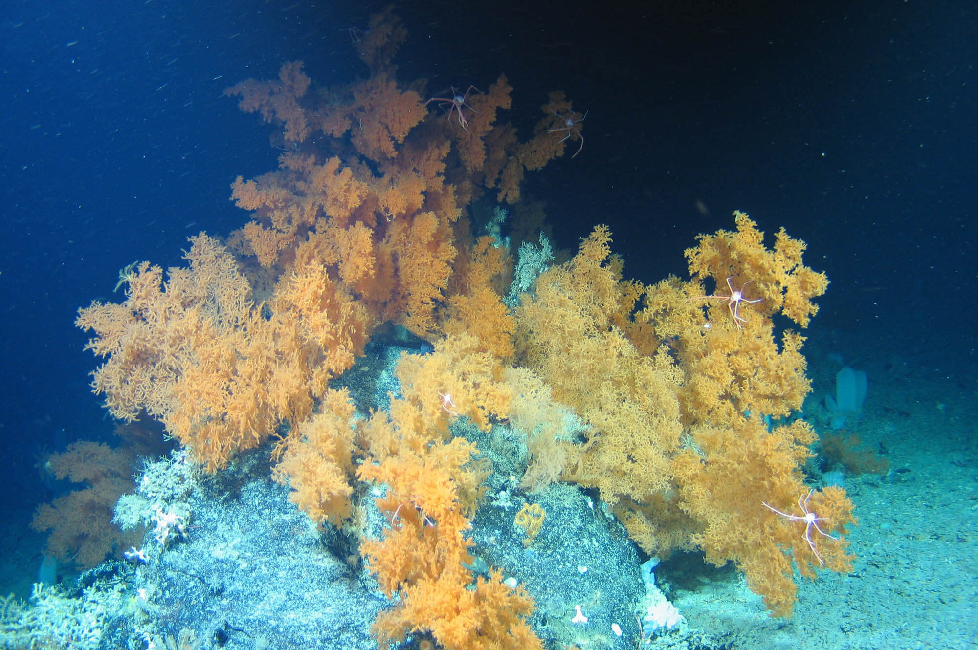
Image courtesy of Eurofleets 2, Marine Institute, University of Plymouth
Can you tell us about the Deep Vision project – what it is, who funded it, and what it involves?
Deep Vision is a project funded by the Bezos Earth Fund’s AI for Climate and Nature Challenge, and it’s really focused on using artificial intelligence (AI) to help us interpret seafloor imagery much faster than we have been previously able. In turn we can identify vulnerable marine ecosystems and map them effectively so that decisions affecting the deep sea can take these into account.
Why is this project so important?
The project is really vital because we are increasingly using our marine environment for economic gain and for lives and livelihoods, and we’re starting to push into areas beyond national jurisdiction – the high seas. These are areas of the Ocean that we really don’t know much about. We don’t have much information from them, but there are these huge archives of video and imagery data that have been collected over the last 20 years by many different organisations. Using the power of AI we can process all of this in a fast and consistent way, giving us important information and providing more observations to help us better understand the deep Ocean.
Why do we need AI for this? What does AI give us that we can’t do currently?
The problem with these large data sets is that they are really time-consuming for humans to analyse. Just to give you an idea, to analyse one dive by an autonomous vehicle might take a human two months of their time, and that’s just one dive. We’ve identified that there are thousands of dives by robotic and autonomous vehicles that have generated imagery, and less than 50% of this imagery has ever been analysed by a human because of how long it takes.
What we’re really aiming to do here is use AI to help us process that imagery much faster and in a more standardised way. Another problem with humans is that humans don’t agree with each other all the time, and they don’t even agree with themselves sometimes if you have a big long time period. You might start out less experienced, you become much more experienced over time, and your interpretation might change.
What AI can also give us is a more standardised processing of imagery. That will make it much easier for us to put data sets together coming from different countries and different organisations, because we know that they will have been interpreted effectively by one mind – the AI – instead of by many, many humans who make errors. We all make slightly different errors, and that’s very hard to correct. A machine will make errors, but it will make those exact errors the same way all the time.
Tell us about the deep sea itself. What are we talking about in this environment? What are some examples of the species that live there?
The deep sea is a really fascinating place, and people tend to think of it as sort of one thing, but it’s not, of course. It’s just part of our ocean – the deep parts. It’s the bit that we know less about, but it’s a very diverse place. It has mountains, it has canyons, it has flat areas, it has ridges. All of the terrain that you might see on land you will see in the deep sea. And so of course the animal life that lives there is hugely variable as well. You don’t get the same animals living in a mountain as you do in a jungle, for example, on land. And the deep sea is no different. It’s a very diverse environment full of many, many different lifeforms, each inhabiting different types of habitat.
Are there specific species you are focusing on?
In this project, we’re particularly concerned about the ones that are vulnerable to human disturbance. They’re often regarded as vulnerable marine ecosystems or vulnerable marine ecosystem indicator taxa. We’re talking about corals, we’re talking about sponges, we’re talking about crinoids. These are animals that will often live in aggregations – they live together in dense numbers and form habitats for other species.
If you think about the deep sea, there’s no light and so there are no plants. On land, our habitats are generally formed by plants. You think of forests, there’s lots of different trees and that’s the habitat for many species. You think of moorland or heathland, and again, it’s formed by different plants. In the deep sea we don’t have plants. What we have are animals that stay still and really perform the function that plants do on land – they’re providing that structure, that three-dimensional habitat. So it’s those animals that we’re really concerned with because they are keystone species. They’re so important for lots of other species that use them as their habitat and their home.
Some people might say, “OK, so there’s a sponge growing in the deep sea. What does it matter to me if it gets wiped out?” What would you say to those people?
People can feel very detached from the deep sea. They don’t see those animals. They might think, yes, there’s just a sponge growing on the sea floor. But what people don’t realise is that these animals do things for us as well. It might be they have a role in sucking up carbon dioxide and sequestering carbon, helping to mitigate climate change. It might be they have a very important role in recycling nutrients. Sponges and corals particularly have an important role in doing that, and those nutrients are then upwelled in upwelling systems back into the surface ocean. And that’s used for growing phytoplankton, which then supports zooplankton, which then supports fisheries.
So our fisheries rely on that nutrient cycling process, and the animals in deep water have a role to play in that process. We may feel like deep sea animals don’t touch us, but they do. It’s just the way in which they do is maybe more difficult to get your head around, but they are vitally important to us.
What makes this project unique? Has something like this been done before?
This is a unique project because no one has really tried to bring this huge amount of data together before for biodiversity at the scale of the Atlantic Ocean. It’s a big challenge and AI is really the way of unlocking it. So this project is really quite unique in trying to do that for the first time. And we hope that if it works in the Atlantic – and we’re very confident it will – it’s something that could then be applied in other oceans around the world.
Are we talking just about historic data or also data that’s being collected today?
The data we’ll be using in this project has really been collected only over the last 20 years because video quality and robotic technology in the deep sea has only really significantly advanced over that time period. Looking forward though, and within this project, we will be collecting new data and using new data that’s collected and applying our trained AI models to those data to help process it much faster. So instead of waiting three years for arriving at some sort of numeric data you can use in analysis, we’re hoping we can cut that down to something a little quicker – maybe six months.
What happens with this information? What impact are you trying to make?
What we’re aiming to do in this project is produce maps of where vulnerable marine ecosystems are in the Atlantic. Those maps are super important because we are going through multiple different processes at the moment that are asking us where we should put marine protected areas, particularly in the high seas, in areas beyond national jurisdiction. But how are we supposed to make those decisions about where’s important to protect if we don’t have maps of what we have and where it is?
The maps that we produce are really important because they are going to help environmental managers make science-informed decisions about where should be protected—where we should put marine protected areas, particularly in the high seas in support of the new High Seas Treaty. These maps will be really important in that respect.
Ultimately what we’re trying to deliver is, as the Ocean Decade puts it, the science we need for the ocean we want. And we hope that this project will support that and support better ocean management in the future.
