Story
Step change for PML’s remote sensing capabilities with new, cutting-edge drone technology
01 April 2025
A state-of-the-art environmental survey drone has been procured to provide advanced environmental survey capabilities in shallow, dynamic and hard-to-reach coastal waters.
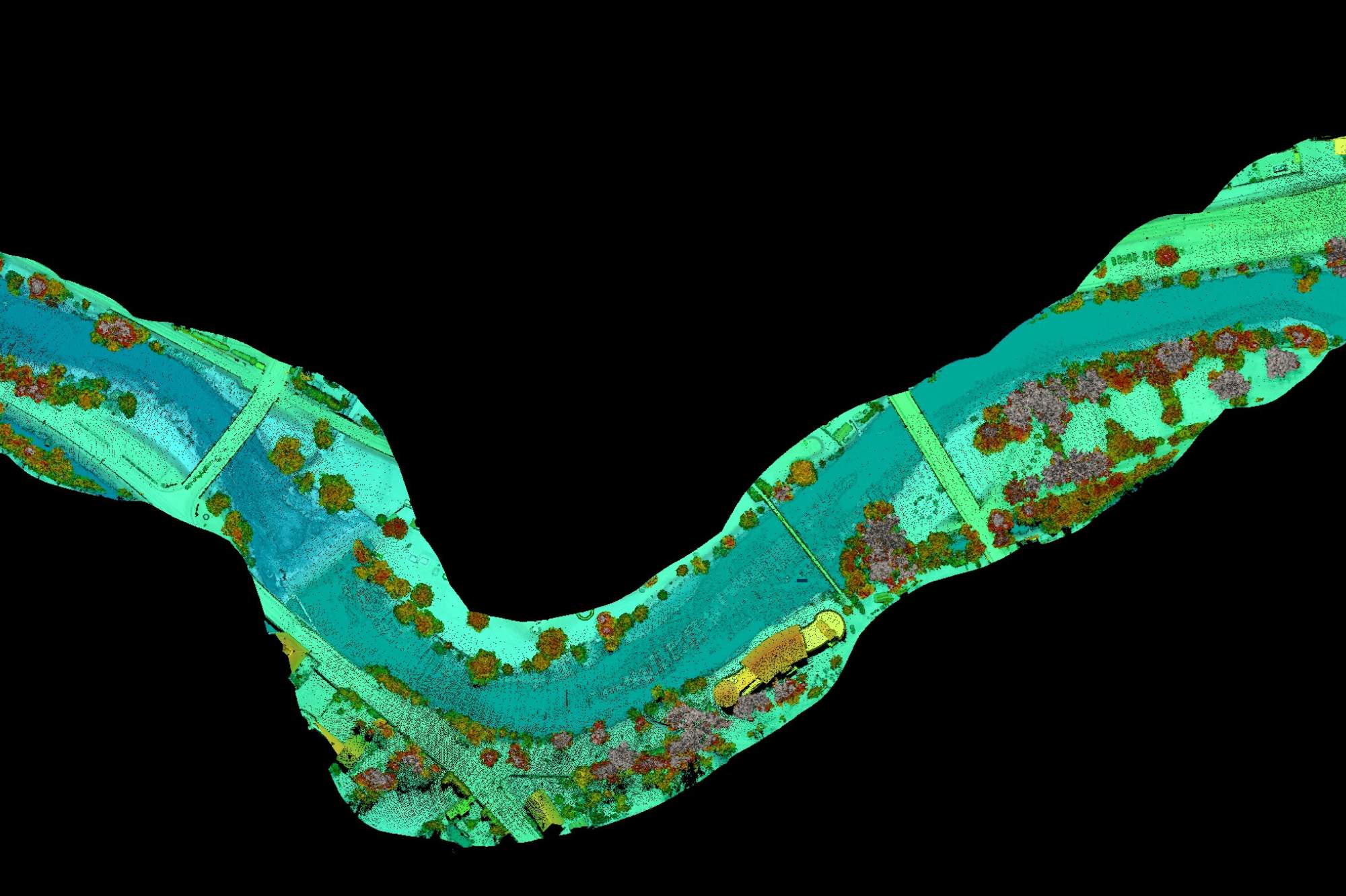
Image above: Examples of the of the 3D model visualization of terrain and bathymetry as collected by the Green LiDAR sensor. © RIEGL https://www.riegl.com/en-uk/
A new PML-led project, funded through the Natural Environment Research Council (NERC) Net Zero Aerial Capability (NZArC) programme, aims to revolutionise how underwater environments are mapped, particularly shallow waters like river sections and coastal areas with low turbidity.
Titled ‘A remotely piloted aerial Green LiDAR for mapping bathymetry of shallow waters and elevation of boundary land (Green LiDAR)’ the project involves collaborations with British Geological Survey, National Oceanography Centre, Scottish Association for Marine Science and the UK Centre for Centre for Ecology & Hydrology, using state-of-the-art aerial equipment to provide underwater mapping (bathymetry) data where other sensors struggle or simply fail to provide solutions.
Aser Mata, Project Leader and Earth Observation Scientist at PML, commented:
“Mapping of shallow waters is especially vital for studying blue carbon habitats such as mangroves, seagrasses, and tidal marshes as these are some of the most efficient natural carbon sinks on Earth. These habitats store and sequester carbon at rates far exceeding tropical forests but mapping their underwater terrain and estimating carbon storage has been a major challenge”.
While bathymetry of the seabed or rivers can be obtained using other boat and instruments such as multibeam echosounders, these sensors cannot be deployed in very shallow waters. To help deliver mapping of ecologically and economically-important underwater environments that are hard-to-reach, the project has allowed for an innovative RIEGL VQ-840-GL Topo-Bathymetric LiDAR sensor to be obtained along with a dedicated third-party drone platform.
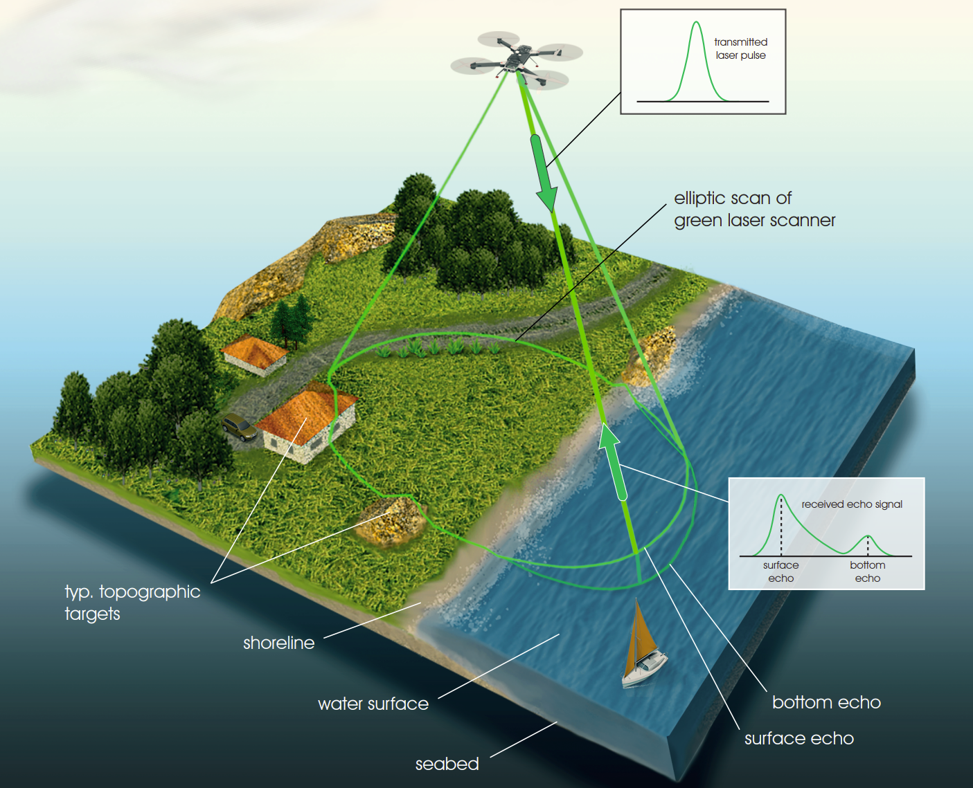
Image above: Diagram of how the RIELG VQ-840-GL Topo-Hydrographic LiDAR sensor works. © RIEGL https://www.riegl.com/en-uk/
This aerial sensor will enable this research to have a reduced carbon footprint compared to the more traditional monitoring solutions that rely on aircrafts or ships, resulting in faster data collection with less environmental impact.
The high-tech sensor uses ‘Unmanned Laser Scanning’, a remote sensing process used to create 3D models of structures and areas. The lightweight, versatile laser scanner offers an estimated penetration depth of nominally 2 Secchi disks, 40 degrees scan angle range, a high-pulse repetition rate of up to 200 kHz and excels in capturing high-resolution data in hazardous or hard-to-reach areas.
Aser added:
“The system will provide the data needed to advance a myriad of scientific challenges that we are currently facing in marine ecosystems. It will allow more precise quantification of coastal erosion and the mapping of blue carbon ecosystems, such as kelp and seagrass, to better understand their lifecycle, improve modelling and estimate how much carbon they store, in turn paving the way to promote the restoration of these habitats for carbon sequestration. It will also help improve models for river flow and river discharge in support of flood prevention”.
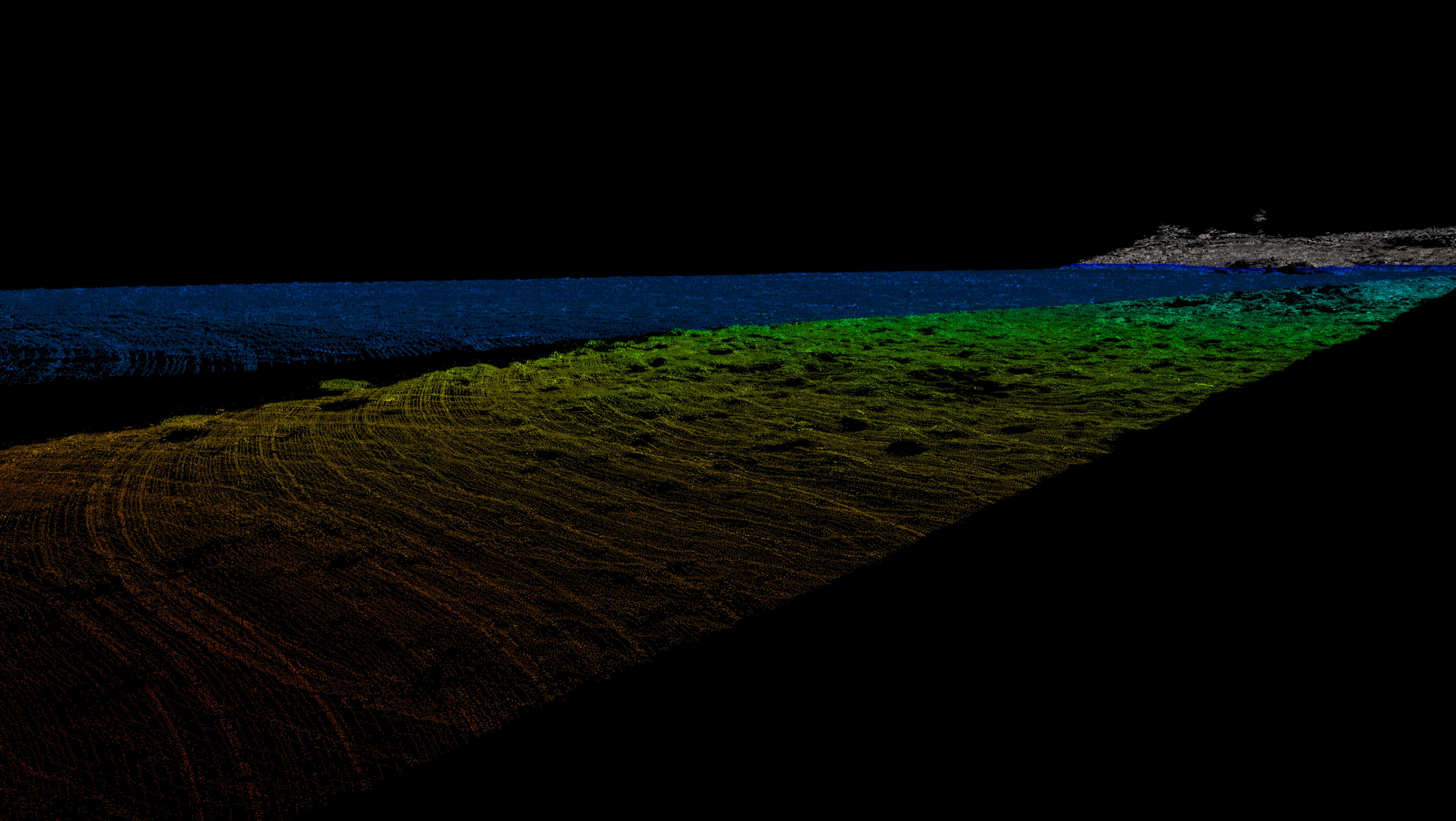
Image above: Examples of the of the 3D model visualization of terrain and bathymetry as collected by the Green LiDAR sensor. © RIEGL https://www.riegl.com/en-uk/
As part of this project, the sensor will be tested and benchmarked against different bathymetric and terrestrial sensors in different environments. The results will be published and made freely available to establish a code of good practices for other projects. Furthermore, the ultimate goal of the project is to make this capability accessible to any researcher in UK that wish to take advantage of this novel sensor via collaboration with PML.
PML has excellent expertise in using drones for environmental studies, including:
- In-land water quality monitoring developing procedures to derive water quality indicators using hyperspectral or multispectral sensors mounted on UASs (project MONOCLE, Windermere) including projects focused on the quality of human health (REVIVAL, Vis4Sea)
- Identification of invasive species, using AI and drone technology to identify Pacific Oysters in UK estuaries.
- Monitoring changes in salt marshes and mudflats (Sharpham and Calstock). Using DEM derived from UAS imagery, sediment accretion and carbon sequestration is estimated for mudflat restorations (project: LOCATE, AgZero+)
- Habitat mapping for seagrass and algae (BICOME) or Kelp (TALISKER). This research will combine UAS data with ML techniques such as ‘random forest’ or Deep Learning for image analysis and object identification for habitat mapping.
- Remote sensing of plastic marine litter over water or on the shoreline. This research is carried out either using RGB cameras or hyperspectral instruments mounted on a UAS (HyperDrone)
The Green LiDAR project itself was one of two projects funded a result of a scoping study that explored the Uncrewed Aerial Systems (UAS) landscape for use in low-carbon environmental science research, in support of the UK Research and Innovation (UKRI) strategy to achieve Net Zero by 2040.
The scoping study report, named Net Zero Aerial Capability (NZArC) Scoping Report: A Review of the Role of Uncrewed Aerial Systems in the Decarbonisation Strategy of NERC Aerial Activities, was co-authored by experts from eight NERC Centres and collaborating institutes, including PML, and provided realistic recommendations on how best to invest in and support environmental science research using these low-carbon technologies and outlined a strategic vision for the future.
The key recommendations included:
- overcoming regulatory hurdles
- building capacity
- fostering technology development
- ensuring data integrity
- enhancing data accessibility
Dr Iain Williams, NERC Director of Strategic Partnerships, said about the report:
“It offers a valuable and comprehensive roadmap for advancing the use and capabilities of UAS to support new insights across the environmental sciences and doing so in a way to reduce the carbon emissions in field research.”
“The report contains some important recommendations and fascinating case studies on the use of UAS in a wide range of environmental science applications. I’m looking forward to seeing the outputs from the two projects linked to this programme and how they may develop new approaches to environmental mapping”.
