Story
PML showcases first ever operational digital twin of the Ocean
25 February 2026
The system was presented at the Ocean Sciences Meeting in Glasgow this week

Ocean surface. Matt Hardy | Unsplash
Scientists at PML led in developing the first operational digital twin of the ocean; a system that forecasts real-world coastal conditions and improves its performance by targeting critical data gaps using marine autonomy.
Coastal marine ecosystems are facing increasing pressure from multiple stressors and working out how best to manage all of these activities, in a way that supports growth but is also equitable and sustainable, is a daunting task.
This seemingly insurmountable undertaking is complicated further by the challenge of predicting coastal marine ecosystems. They change rapidly, monitoring efforts can be sparse and there is rarely a complete picture of the many environmental variables and human activities that affect the entire ecosystem.
A virtual representation that can update dynamically to environmental and human pressures would enable more accurate monitoring and prediction of future conditions. It would also allow testing of management and policy interventions, including those related to climate mitigation and adaptation and incident response.
Developing a digital twin
In the SyncED-Ocean project, part of the NERC–Met Office funded Twinning Capability for the Natural Environment (TWINE) programme, PML scientists have been working with partners to develop such a system. This system accurately simulates the highly complex and dynamic coastal marine environment and improves its performance by autonomously identifying and targeting critical data gaps.
The team drew on PML’s world-leading understanding of whole ecosystem functioning, including physical, chemical, and biological processes, along with expertise in human-induced pressures on the marine environment. Using this expert knowledge, they developed a transferable digital twin framework and successfully conducted a 2-month autonomous demonstrator in the Western English Channel, an area prone to harmful algal blooms (HABs) and associated low oxygen conditions.
The system combines data collected from a wider range of sources, including autonomous ocean gliders and buoys, research vessels and satellites, all integrated through the SyncED-Ocean Data Architecture. A key part of this work was ensuring that all incoming data were processed to the highest possible standard, with real‑time quality control applied to the glider data and appropriate flagging of any low‑quality or uncertain measurements.
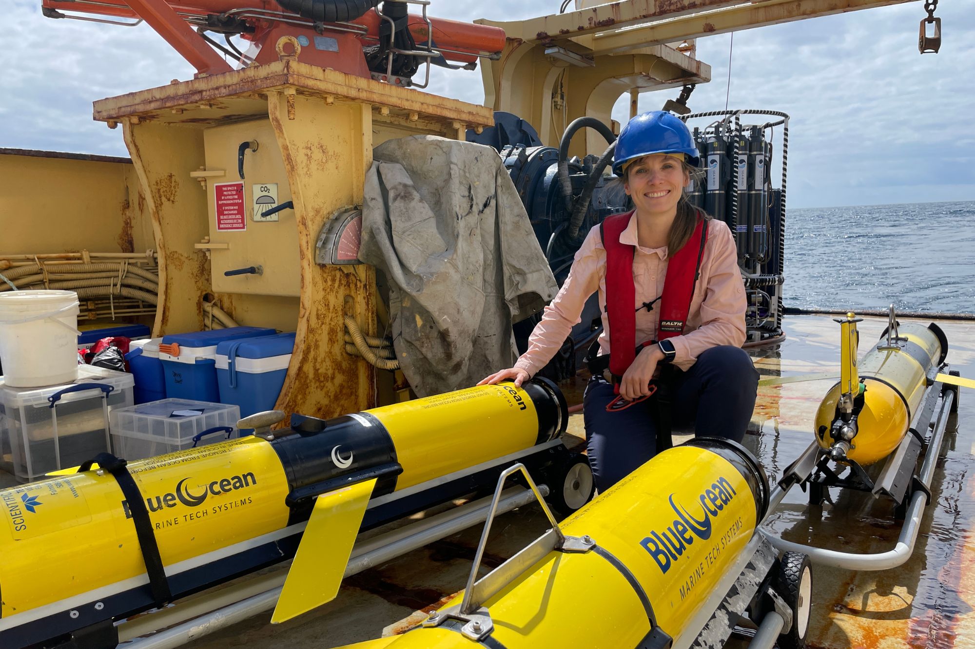
Above: Dr Juliane Wihsgott on board the PML Research Vessel Plymouth Quest alongside 3 robotic gliders just prior to deployment for the SyncED-Ocean project. Discover the fieldwork >>
The architecture uses a federated approach that converts each dataset into machine‑readable, standardised formats, helping to manage the significant variation in parameters, metadata and quality standards across different sectors, organisations, technologies and countries.
This combining drastically increases the value of the individual data sources by creating a single quality-controlled and standardised data repository that can then be used to inform the virtual system and produce more trustworthy forecasts.
Putting the ‘auto’ in marine autonomy
A central element of the system was demonstrating true two‑way communication between the real ocean and its virtual counterpart. An AI-based component identified where forecasts were most uncertain and needed further observation to improve the forecast and gliders received new waypoints automatically every 24 hours to target these priority locations. This secure closed‑loop cycle of predict, observe and update represents a major shift toward fully-operational digital twin systems.
These targeted glider data were transferred in near‑real time, combined with satellite measurements and assimilated into a coupled physical–biogeochemical operational model run by the Met Office. This produced daily predictions of chlorophyll-a and oxygen, giving early insight into likely changes in productivity and potential HAB risk. This is useful for researchers, governments and industries to anticipate changes in marine conditions, manage resources sustainably and understand climate change impacts on a timescale of months to decades.
So much more to sea
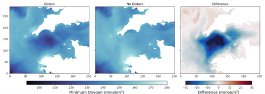
The performance of this new system is highly encouraging and it has already revealed important observations that would have been missed under traditional data collection, which in turn helps improve the predictive skill of the associated model.
These improvements extend beyond immediate reduction of bias and error in the assimilated data to recognisable improvement over the short-term forecast period. With the inclusion of these targeted marine autonomous observations, instances where the forecast predicts the crossing of a key threshold also increases in both chlorophyll and dissolved oxygen, highlighting the potential to capture extremes more readily and accurately.
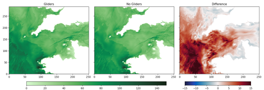
Integrated chlorophyll Mg/m2
Dr Juliane Wihsgott, Digital Oceanographer at Plymouth Marine Laboratory and lead scientist on this research, commented:
“This continual two-way coupling between real and virtual counterpart, driven by a continuous feedback loop of measure, predict, direct and refine, is a world-first approach that demonstrates how fleets of autonomous ocean ‘robots’ could target the right observations at the right time, and help improve both our forecasts and our understanding of the system. By focusing effort where it matters most, we can observe key processes at the scales they actually occur and build a much more accurate picture of changing marine conditions in near real time.”
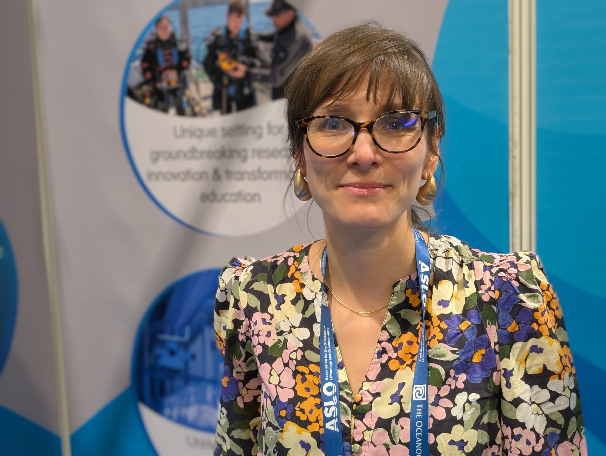
Image: Dr Juliane Wihsgott at the Ocean Sciences Meeting held in Glasgow this week, where she presented this research.
Dr Thomas Mansfield, Data Systems Architect at Plymouth Marine Laboratory and participant in the study, added:
“This pilot deployment provided us with such a wealth of useful information that will help refine this innovation. Key lessons learned include the need for rigorous engineering and testing in data integration and management, ensuring resilience against erroneous data. Trade-offs between data timeliness and quality were also noted and necessitate a redesign of workflows to meet strict operational timeframes while maintaining data integrity. Additionally, despite automation, a level of human monitoring remained essential for overseeing data pipelines and machine learning decision-making. These insights provide valuable guidance for future environmental digital twins, enhancing scientific understanding and supporting sustainable marine management.”
Next the team plan to: improve efficiency and reduce cost in both the numerical modelling and the machine-learning component that guides the path-planning of the marine autonomy; expand adaptive sampling to additional variables, platforms and environmental use cases; deliver actionable evidence for compliance, impact assessment and resilience planning, and strengthen stakeholder engagement through co‑design and operational feedback.
A further focus will be delivering practical evidence for compliance, impact assessment and resilience planning through an interactive visualisation tool (link here). This will include how targeted observations, guided by a digital twin approach, could support monitoring the impacts of expanding offshore wind alongside other marine pressures.
Related information
This research was presented by Dr Juliane Wihsgott at Ocean Sciences Meeting (OSM) in Glasgow this week.
Find out more about the PML research being showcased at the OSM >>
