Story | 09 October 2026
What is El Niño, how does it work and what will it do?
PML’s Dr Lee de Mora explains the science behind El Niño and explores how it could shape weather around the world – and here in the UK.
Image credit: NOAA via Unsplash
By Dr Lee de Mora. Dr de Mora is an Earth System Modeller at Plymouth Marine Laboratory (PML), where he uses complex computer simulations to forecast what our future ocean and climate may look like.
In recent news, you may have seen the alarming headlines that the anticipated El Niño is unprecedented, strongest in living memory, or supersized.
But, what is El Niño? What does it mean for people and nature around the world – and in the UK? And, how may climate change affect El Niño events in the future?
Quick links in this article:
Background: what is El Niño? And how does it work?
The name El Niño, which translates in Spanish to “the boy”, is thought to have originated with South American fishermen who first recognised periods of unusually warm water in the Pacific Ocean as early as the 1600s.
The full name used by fishermen was “El Niño de Navidad”, which translates to “The Christmas Child” or “The Christ Child” because El Niño typically peaks around December and the Christmas period.
As such, El Niño is not a new phenomenon – but a naturally occurring climate fluctuation that happens when the ocean and the atmosphere in the Tropical Pacific Ocean interact in unusual ways.
What happens in the Pacific under normal (non- Niño) conditions?
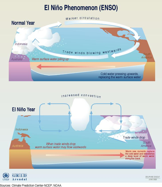
In normal non-Niño conditions, the wind blows from East to West along the equator in the Pacific Ocean. These winds are known as trade winds and push warm surface water westwards towards the western Pacific.
In the Eastern Pacific, the water that was pushed westwards is replaced by deep cooler water, ‘upwelling’ from below the surface layers. With cool upwelling waters in the East, and warmer waters in the West, there’s a steep temperature difference between the two regions.
At the same time in the atmosphere, the warm water in the western Pacific has warm surface air above it. The warmer air is more buoyant so rises, forming both rainclouds and a lower pressure region. Due to air naturally flowing from areas of higher pressure to lower pressure, this difference between the cooler east and warmer west acts like a pump, reinforcing the trade winds that already blow in that direction.
This self-reinforcing non-Niño can persist for years at a time and gives us the more typical and predictable weather systems to which we are accustomed.
How does El Niño begin?
The El Niño cycle stars with a weakening of the trade winds. This can be caused by a small initial disturbance, such as a burst of winds travelling east rather than west, that disrupts the delicate balance. This results in less force pushing the warm waters westward and they start to bunch up along the equator from West to East, kind of like cars lining up in a traffic jam. This is known as a ‘Kelvin Wave’ and it can take just a couple of months to cross the entire Equatorial Pacific Ocean.
As the bunched up “traffic jam” of hotter water reaches the Eastern Pacific, the upwelling weakens, making it even harder for cold deep water to reach the surface so the warm water accumulates and makes the Eastern Pacific warmer than usual. The air above it is lighter so it rises, generating towering convective clouds and heavy rainfall. The rain that would normally have fallen further west, now falls in the East.
This is where the process becomes self-perpetuating and begins driving momentum itself; when air is rising and forming these towering convective clouds, it pulls in air at the sea surface, which further weaken the trade winds. In turn, this causes heat to build up even more in the East, which then causes air to rise into tall rain clouds, sucking air towards them, which then weakens the trade winds, causing more heat to build up!
This self-reinforcement is why just a small change in the trade winds can lead to a much larger El Niño event.
How can El Niño affect weather around the world?
‘If you want to understand how interconnected our planet is, how patterns and events in one place can affect life half a world away, study El Niño’. [Source: NASA]
A strong high-altitude wind, known as a subtropical jet steam then redistributes the effect around the globe.
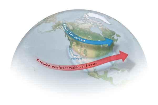
This can have globally ranging impacts, such as changing where rain falls that can lead to floods or droughts. It also changes where wind blows, which affects the ocean mixing, upwelling and how much nutrients are available for phytoplankton. It also impacts where heat moves in the ocean and atmosphere, leading to cold snaps or heat waves on land and in the ocean, as well as shifting how storms travel and how powerful they become.
How strong is a “strong” El Niño?
These impacts are all tied to how strong the El Niño is: the more heat that gets held up in the Eastern Pacific Traffic jam, the bigger the changes can be elsewhere.
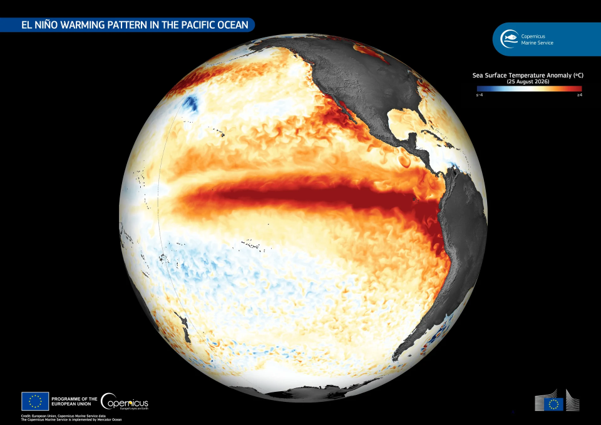
We measure the strength of the El Niño by keeping track of the changes in Sea Surface Temperature of the Pacific around the Equator. More precisely, we track the average temperature of the “Nino3.4” region, which covers 5°S to 5°N, and 170°W to 120°W.
Typical El Niño temperature rise
Reported 2026 temperature change
An exceptional El Niño event
A typical El Niño has a temperature rise in this region of 1 to 2 degrees. The 2026 El Niño event has seen a temperature change of over 3 degrees Celsius, and this is largest ever recorded.
We are truly in uncharted territory and it is the combination of the El Niño’s natural variability and anthropogenic climate change that will likely lead to extreme weather events in 2026 and 2027.
How does climate change supercharge El Niño?
This is still an area of active research but El Niños have become over 36% stronger than they were in the pre-industrial period. Under climate change, the baseline non-Niño conditions are warmer. This means that when El Niño releases heat into the atmosphere, it is adding extra warmth to an already warming climate. This is one of the reasons why scientists are predicting that 2027 could be the hottest year on record.
In addition, warming may not be distributed evenly across the equatorial Pacific and models generally predict that the ‘east to west’ temperature gradient is expected to weaken under climate change. This changes how the pacific responds to El Niños and may make it easier for the heat ‘traffic jam’ to occur.
Another factor to consider is that warmer air can hold more water vapour, which can produce more extreme rainfall events. At the same time, regions that are facing El Niño-related droughts may be subjected to greater extremes, as the baseline temperatures are already elevated.
The relationship between climate change and El Niño are still unclear but there is increasing evidence that a warmer world will amplify the extreme impacts of El Niño.
What could El Niño mean for the UK’s weather?
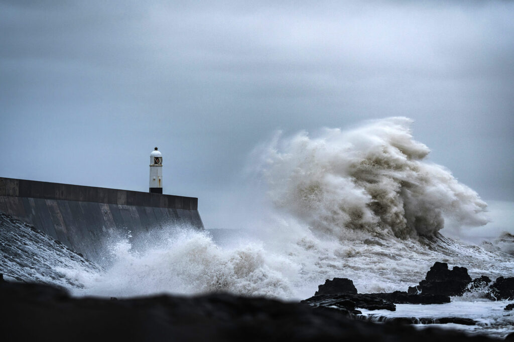
Historically, El Niño winters start windier, wetter and warmer, and the late winter is colder and calmer in the UK. The Met Office says that the UK’s weather is likely to be impacted by the supersized El Niño, with the Autumn and Winter being wetter and stormier than usual. This means that there’s more chance of strong winds, excessive rainfall and higher risk of flooding.
So we know that the El Niño is indeed the largest ever recorded so why can we not say for sure how it is going to affect us this winter?
Basically, the El Niño is happening thousands of kilometers away and has to cross half the planet, including several large land masses and oceans, before it gets to us. Its influence reaches the UK through a fairly long chain of interactions to get from the Equatorial Pacific Ocean, and each connection adds some amount of uncertainty.
The chain connecting El Niño and the UK could be something like: the Pacific sea surface warms, which leads to changes in Pacific atmospheric circulation and convection, which leads to changes in the Pacific jet streams, which propagate through the atmosphere, which impacts Atlantic storm tracks, and this impacts the North Atlantic Oscillation, which then influences the UK’s storms, wind and precipitation.
These long-distance connections are known as teleconnections and, although they are well established, their precise strength and timing can vary considerably from one event to another. While we can be confident that this exceptional El Niño will have effects around the world, we cannot predict exactly when, where or how strongly those effects will be felt in the UK and Europe.
Current forecasts suggest an increased likelihood of wetter, stormier and warmer conditions in north-west Europe during autumn and early winter. However, other climate drivers can reinforce or counteract the El Niño signal and the eventual winter weather will depend on how all of these factors interact.
Enjoy this article? You may also like the explainer article, ‘What is AMOC? And what is the North Atlantic ‘cold blob’? PML’s Dr de Mora breaks down the science’ – another from Dr de Mora.